Every Leopard skipper is an adventurer. The Leopard life plays out on a never-ending course of personal exploration, enrichment and fun. As you plot out 2020, take a moment to look over this list of the highest-rated anchorages of 2019, as described by members of Garmin’s ActiveCaptain community. Here you will find reviews of both destinations and lay-over spots from Maine to Croatia, St. Bart’s to the Greek Isles. If you find this guide useful - and you will - consider sharing your travel experiences and insights as a member of the ActiveCaptain community.
US East and Gulf Coasts
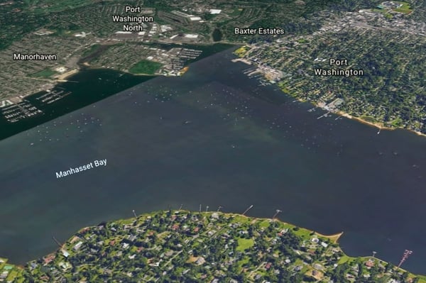
Situated in Manhasset Bay off the East River, Port Washington gets rave reviews as an ideal stop-over for transient cruisers. The 20 city-operated yellow mooring balls are free for two days, $25 per day after that. Anchoring outside the mooring field is also permitted. One ActiveCaptain reports “excellent holding, current and wind protection from all directions” at an average 12’ depth. Use the water taxi or dinghy dock to visit Port Washington, which is an excellent place to provision. This cruiser-friendly town has a grocery store, two hardware stores, a West Marine, laundromat, and plenty of good restaurants. Up for a Big Adventure? New York City is just 40 minutes away from Port Washington’s train station. In the opinion of one happy cruiser: “This town has cracked the code on how to attract transient cruisers and hold them captive for a few days with natural beauty, personal charm and great service. Port Washington is a model town for hosting and serving the cruising public. We will be back.”
Click here for more information about Port Washington
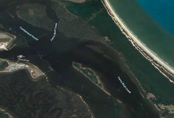
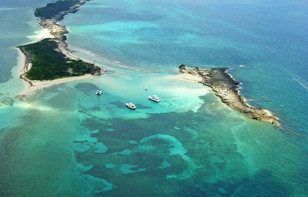
This large anchorage is located off the Intracoastal Waterway near Cumberland Island National Seashore. Cumberland, a large barrier island, is a designated wilderness area accessible only by boat. Visitors throng to the island for both its abundant natural beauty, wild horses, and numerous historic sites, including the remains of a Carnegie family vacation estate. Cumberland Island is easily accessible by dinghy from Cumberland Sound. The anchorage offers good holding in about 9 - 22 feet of depth and protection from the east. Stay to the western side of the channel to anchor as vessel traffic from the north runs the eastern side of the channel. ActiveCaptain Delphinia says Cumberland Sound is an ideal anchorage: “What an amazing spot. Anchored just north of the ferry dock in 22’of water. Great holding and the island is amazing. Short walk to miles of beach and wild horses on the sand dunes! Pets are welcome!”
Click here for more information about Cumberland Sound
https://activecaptain.garmin.com/pois/17686
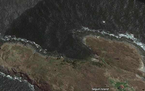
Seguin Island is home to Maine’s second oldest lighthouse, which today doubles as both navigational aid and tourist attraction. Seguin is accessible by only one cove, which is well protected from the south but exposed to the north and somewhat to the east.
Anchoring is not permitted in the cove. Cruisers must use one of a handful of Coast Guard moorings, some of which are steel. ActiveCaptains who have visited Sequin recommend wrapping an old lifejacket around those moorings to prevent hull scrapes. ActiveCaptain Sawyer Balint, whose craft draws 6.5 feet, urges larger sailboats to avoid the inner moorings due to the wide tidal range. Once your boat is set, prepare for a delightful time on the island, including a tour of the lighthouse and perhaps a trail hike. Seguin is the perfect day trip according to one ActiveCaptain: “Visiting Seguin Island on a sunny day is a must. There are 3 or 4 different walking trails, little overlooks/vistas, a maintained composting toilet, and, last but not least, a fully functioning lighthouse. The welcoming caretakers were eager and happy to give our two small children and us a tour. We walked up the winding stairs of the lighthouse and stood on a balcony overlooking the Atlantic.”
Click here for more information about Seguin Island
https://activecaptain.garmin.com/pois/43961
This small anchorage (three-four boats, max) is an ideal layover spot while cruising the Chesapeake Bay. ActiveCaptains report good wind protection, excellent hold, and 9-foot depths. You can dock your dinghy at the Holiday Inn ($2) while you stretch legs and re-provision onshore. There’s a West Marine, a supermarket ($5 Uber), restaurants, and even a small museum featuring fossils from the Chesapeake’s pre-boating era. A local ActiveCaptain says Solomons-5 is a favorite spot. “We have anchored here several times over the years and have always found it to be a great spot with good holding and wind protection from the high trees on the shoreline. It’s in a no-wake area, so it is mostly calm. If we get to Solomon's late in the evening, we anchor here and then Spring Cove Marina the following day.”
Click here for more information about Solomons-5
https://activecaptain.garmin.com/pois/44527
Bahamas
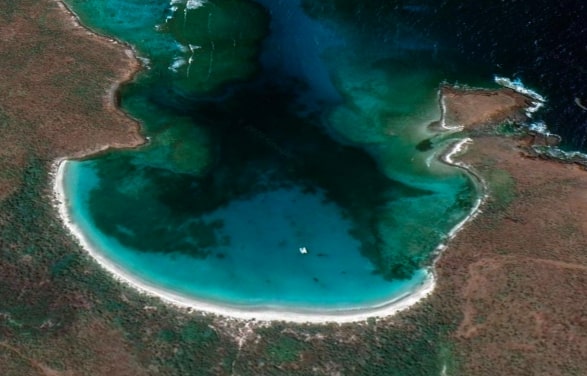
This twin beach anchorage offers good holding in sand. Depths vary from 5 to 12 feet depending on closeness to the beach, and the anchorage is protected from Northeast through Southeast. This is a quiet area, with the calm broken only by the occasional tour boat. The blue water makes for great snorkeling with rays and dolphins making regular visits to the area. The shore offers pristine beaches and hiking trails, one of which will take you to the highest point in the Exumas. ActiveCaptain Bill 91126 has become a regular at Williams Bay. “We have been here several times this season, and we can't stay away. Holding is excellent, and protection is good even with moderate squalls from the south. Clear water, excellent beaches, good shallow water snorkeling in the nearby bays make it a multi-day destination.”
Click here for more information about Williams Bay
https://activecaptain.garmin.com/pois/47794
This is a large anchorage with good protection Northeast through Southeast and water depths greater than 6 feet. The sand and grass bottom offers generally good hold. Pass your time snorkeling, exploring the nearby mangrove estuary, walking a nearby trail, or lolling on the beach. The local residents are welcoming of cruisers and ask only that you pick up trash and keep your dog on-leash to protect their chickens.
Click here for more information about Manjack Cay South
This gorgeous anchorage is the ideal spot for spotting sea life. The clear blue water teams with rays and sharks. The anchorage has a minimum 6-foot depth, good hold, and protection from the south. This idyllic location is usually low-key during the week. However, it can get crowded on the weekends, especially in summer, when revelers from Miami show up in force. ActiveCaptain SeaMonsterL40 is head-over-heels for Honeymoon Harbor. “We absolutely loved it here. I saw a tiny reef shark while diving the anchor and a large nurse shark shortly after. We took SUPs into the beach to catch all the rays (and some nurse sharks) swimming near the dock. Simply amazing how many of them there are and how they come right up to you. Would definitely return just for this experience.”
Click here for more information about Honeymoon Harbor
https://activecaptain.garmin.com/pois/42399
If George Town and Stocking Island are on your punch list, Sand Dollar Beach is a great anchorage. The water is 17-25 feet deep (one reason pirates loved this spot), the hold is good, and there is protection from the north and east. The shops and restaurants of George Town are a dinghy ride away with all the luxuries of a Four Seasons Hotel just down the road. Snorkelers and divers love Stocking Island’s blue holes, coral gardens and undersea caves. The island is also home to Stromatolites, said to be the oldest known macro-fossils on the planet. ActiveCaptain Jeffrey Siegel enjoyed his long stint at Sand Dollar. “We stayed here in the same spot for six weeks, including the Cruiser's Regatta week. The anchorage is quite safe. We experienced all types of weather, with winds from every direction up to about 40 knots. Most of the boats here are well spaced and considerate. It's a nice place to be close to the action but not in the middle of it.”
Click here for more information about Sand Dollar Beach
https://activecaptain.garmin.com/pois/40586
The snorkeling members of the ActiveCaptain community can’t say enough about this day-time mooring spot, which borders a robust, healthy coral reef that runs for hundreds of yards. Here you will see schools of tropical fish, rays, small sharks, turtles and countless varieties of coral, including sea fans. B Carey’s comments and advice echo her fellow ActiveCaptains: “I snorkeled this spot twice, and both times it was great. It’s the best snorkeling I’ve experienced with an abundance of wildlife and coral, including Spotted Eagle Rays. Go at slack tide. If there is any wind from the east, this is probably not very doable as the waves and roll from the ocean can be considerable. Boats up to 24’ can moor near the reef for free.
Click here for more information about Snorkeling mooring
https://activecaptain.garmin.com/pois/68735
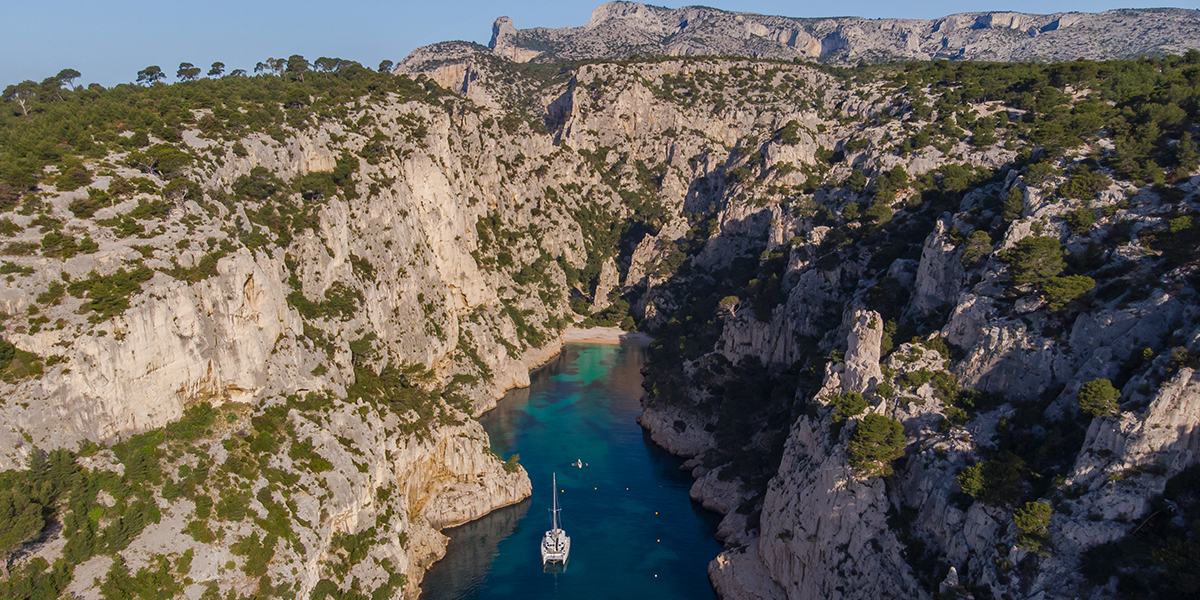
Caribbean
.jpg?width=655&name=Screen%20Shot%202020-01-29%20at%2012.42.22%20PM%20(1).jpg)
This secluded location is ideal for snorkeling, beach time, or a bit of hiking. There are 20 mooring balls and plenty of room for anchoring. The hold is good, and the anchorage is well protected, except for Southeast. Local officials might double-check your anchorage as part of their effort to protect the area’s considerable sea turtle population. The small town of Anse de Flamandes is a 30-minute walk away. From there you can catch a taxi to Gustavia, the capital of St. Bart’s. This ActiveCaptain loved their brief time at Anse de Columbier: “We stayed here for two nights after leaving the busy harbor in Gustavia. We easily picked up a mooring first thing in the morning as others were departing. Breakfast was interrupted many times by curious turtles who swam by smiling. Good swimming. It was hard to leave such a picturesque spot.”
Click here for more information about Anse de Columbier
https://activecaptain.garmin.com/pois/38370
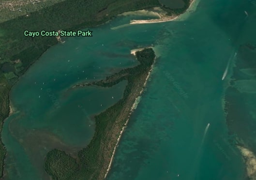
Cayo Costa State Park encompasses an entire Florida coastal island. Its nine miles of undeveloped shoreline is perfect for swimming, snorkeling, shelling, fishing and birdwatching. The local residents include alligators, manatees, porpoises and sea turtles. Explore the island’s interior via several walking and bicycling trails that traverse Cayo Costa. The park’s Pelican Bay anchorage can be tricky to access (stay close to the north shore), but the hold and protection are solid. A dinghy dock provides entry to the park. ActiveCaptian Steady2 sings high praise for Cayo Costa. “We've been underway for a year, and this has to be one of the best anchorages from Maine to Florida! State Park is well worth a visit, especially for beach lovers. Pay attention and follow the instructions on your way in and you will have at least 5.5 feet of water all the way. On a sunny day or clear night, this place is stunning. AND the anchor comes up clean!”
Click here for more information on Cayo Costa State Park
https://activecaptain.garmin.com/pois/17551
Culebrita has eight free mooring balls (labeled for day use), and plenty of room to anchor. There is good hold and protection in every direction except NNE. A North swell can make things a bit rolly. This anchorage is popular with tour boats and partiers and can get crowded on the weekends. The snorkeling is good, and sea turtles abound. On shore, you will find several hiking trails. One of those paths leads to the ruins of the 19th-century Culebrita lighthouse. One ActiveCaptain called Culebrita “the most beautiful beach I have seen in the Virgin Islands,” adding, “We took a mooring ball late night in January and woke up to a beautiful beach and crystal-clear water! Can't explain it. One of those places you have to see for yourself. Yes, it was a day mooring ball, but we stayed tied to it one more night. No one else was around. This is paradise at its finest.”
Click here for more information about Culebtita Island
https://activecaptain.garmin.com/pois/47691
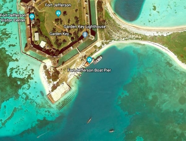
The Dry Tortugas, so-named because of their lack of freshwater, are located in the Gulf of Mexico some 63 miles west of Key West. The seven islands and surrounding waters fall entirely within Dry Tortugas National Park. This anchorage is located off Garden Key, site of Civil War-era Fort Jefferson. Once you’ve seen the historical sites, consider partaking in some of the islands’ excellent snorkeling. Despite its exposed location, the spot has decent protection. Hold can be an issue in the 6-10 foot deep water, according to several ActiveCaptains. “Well worth the trip” is how one ActiveCaptain describes the Dry Tortugas. “We stayed here two days - very tight anchorage, seaplane comes and goes about four times a day,” reports another. “A nurse shark hung out under our boat the whole time. The rangers are extremely helpful and very polite. The ferry comes in around 10 am, and you can enjoy a buffet lunch on board! Overall had a great time exploring the fort and reefs!”
Click here for more information about the Dry Tortugas
https://activecaptain.garmin.com/pois/40204
Mediterranean
.jpg?width=600&name=Screen%20Shot%202020-01-29%20at%2012.12.58%20PM%20(1).jpg)
The picturesque village of Trikeri is located at the southern tip of the Pelion Peninsula. The town and nearby namesake island offer plenty to see and do. Trikeri has some good restaurants, cobblestone streets, and two 18th century churches. The sparsely inhabited island engages visitors with gorgeous views from its many hiking trails, a few shops and taverns, and a sprawling old monastery. At least one restaurant in the village offers mooring at its dock. There is plenty of room to anchor in water 32’ to 50’ deep.
Click here for more information about Trikeri
https://activecaptain.garmin.com/pois/69597
.jpg?width=600&name=Screen%20Shot%202020-01-29%20at%2012.18.16%20PM%20(1).jpg)
Isla Cabrera, a Spanish National Park located about 30 miles southwest of Palma, is rich in both history and natural wonder. Access to the island is restricted; anchoring is not allowed in the surrounding waters. This bay is one of the few permissible mooring areas around the island. There are roughly 50 mooring balls that must be reserved in advance and are well-supervised by park staff. Because of its isolation, Isla Cabrera has remained largely unchanged over the centuries and remains home to many seabird species that have become scarce in other coastal areas. Explore the island on foot to get a sense of its deep history, which is symbolized by the 14th century Cabrera Castle. The waters around the life team with magnificent sea life, including several species of whales, dolphins and loggerhead turtles. The diving is excellent but highly regulated by a permit system.
Click here for more information about Puerto de Cabrera
https://activecaptain.garmin.com/pois/44753
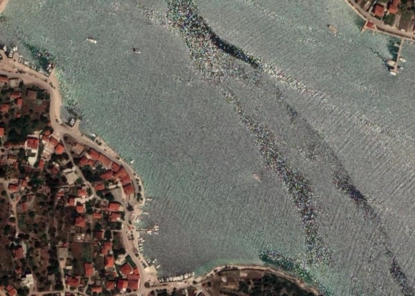
Vinisce is a quaint village on the shores of a beautiful bay, southwest of Trogir. The town’s restaurants and atmosphere make it a great overnight stop. If you have time, consider a day trip to Krka National Park, famous for its seven waterfalls, ancient monastery, and Roman catacombs. This anchorage offers a good hold in about 20 feet of water and protection North, South and West. One ActiveCaptain describes Vinisce as “a really nice bay for a lunch or overnight stop.”
Click here for more information about Vinisce Bay
https://activecaptain.garmin.com/pois/72685
.jpg?width=600&name=Screen%20Shot%202020-01-29%20at%2012.28.28%20PM%20(1).jpg)
Situated alongside Antiparos, Despotiko couldn’t be more different from its popular neighbor. While ongoing archeological work on the island indicates Despotiko may have been a bustling hub in the Bronze Age, it is currently uninhabited and dry. This anchorage offers good hold and protection in 10 to 20 feet of clear water. There’s a small restaurant onshore, and you are free to wander the ancient remains unearthed by archeologists. For more options, take the ferry to Antiparos. But make sure you get back in time to enjoy the stargazing from Despotiko.
Click here for more information about Despotiko
https://activecaptain.garmin.com/pois/77330
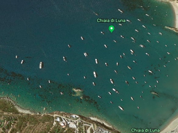
Low-key, unpretentious Ponza is said to be the favorite island destination of “real Romans,” not to mention Jay-Z, Beyonce and Rihanna. The island’s picturesque villages sit amidst a stunning landscape of craggy rock formations and steep cliffs.
All surrounded by mesmerizing blue water. The Chiaia di Luna anchorage is set below one of those cliffs. The sandy bottom provides a good hold while the cliff provides excellent protection. There is one downside to that rock wall: “The beach is cordoned off due to the fragile cliff face,” according to ActiveCaptain janeK. “But a walk through the rock tunnel to the left of the wooden beach bar, takes you into the town, on the easterly side of the island.”
Click here for more information about Chiaia di Luna
https://activecaptain.garmin.com/pois/18964